In the ever-evolving world of aviation technology, Garmin has consistently been a frontrunner in delivering cutting-edge solutions to pilots worldwide. The Garmin Aera 660 stands out as a testament to their commitment to excellence, offering a robust and feature-rich portable aviation GPS that caters to the diverse needs of aviators. This review will delve into the key aspects of the Garmin Aera 660, exploring its design, user interface, connectivity features, mapping capabilities, and navigation aids, providing a comprehensive overview of this remarkable aviation tool.
Exploring the All-in-One Ergonomics of the Garmin Aera 660’s Rugged Design and its Sunlight-Readable 5-Inch Screen
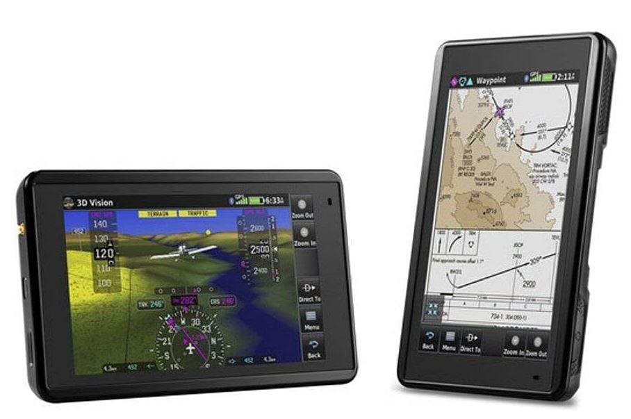
The first impression of the Garmin Aera 660 is its robust and durable design. Constructed with the demands of aviation in mind, the device exudes a rugged quality that instills confidence. Its compact form factor makes it an ideal companion for pilots who value portability without compromising on functionality.
One of the standout features is the sunlight-readable 5-inch touchscreen display. Pilots often find themselves contending with varying lighting conditions in the cockpit, and the Aera 660 addresses this challenge effectively. The high-resolution screen provides crisp and clear visuals even in bright sunlight, ensuring that critical information is always accessible without any visibility hindrances.
Navigating with Ease: Insights into the Intuitive Touchscreen Operation and User-Friendly Power Button
Navigating the Garmin Aera 660 is a breeze, thanks to its intuitive touchscreen interface. The responsive display allows pilots to effortlessly input commands, browse through menus, and zoom in on maps with a simple touch. The user-friendly layout ensures that essential functions are easily accessible, enhancing the overall user experience.
In addition to the touchscreen, the Aera 660 features a thoughtfully placed power button that adds to the device’s convenience. Situated on the top of the unit, the power button is easily reachable, allowing pilots to turn the device on or off with minimal effort. This attention to ergonomic design reflects Garmin’s commitment to creating tools that seamlessly integrate into the pilot’s workflow.
Visualizing Flights in 3D Vision Perspective for Enhanced Situational Awareness
Situational awareness is paramount in aviation, and the Garmin Aera 660 takes it to the next level with its 3D Vision perspective. This innovative feature provides pilots with a lifelike representation of the terrain and obstacles, offering a more comprehensive understanding of the surroundings. The 3D visualization enhances spatial awareness, allowing pilots to make informed decisions in real-time and navigate through challenging landscapes with confidence.
Leveraging Wireless Connectivity with Connext for Real-Time Weather and Traffic Data
The Aera 660’s connectivity capabilities set it apart from conventional aviation GPS devices. Garmin’s Connext technology enables wireless communication with compatible devices, providing real-time weather and traffic data. This feature proves invaluable during flights, allowing pilots to make dynamic adjustments based on the latest information. The seamless integration of Connext enhances overall safety and efficiency by keeping pilots informed of changing conditions throughout their journey.
Streamlining Updates and Saving Costs with Wi-Fi Enablement for Effortless Database Downloads
Keeping aviation databases up-to-date is crucial for safe and accurate navigation. The Aera 660 simplifies this process by incorporating Wi-Fi enablement. This functionality allows pilots to effortlessly download database updates, saving time and reducing operational costs associated with manual updates. Garmin’s commitment to streamlining essential tasks is evident in this feature, contributing to the device’s overall efficiency.
Preloaded Essentials: Flight Mapping, Terrain Awareness, SafeTaxi Charts, and Airport Directories at Your Fingertips
The Garmin Aera 660 comes preloaded with a wealth of essential information, making it a comprehensive tool for pilots. Flight mapping capabilities provide detailed route planning, while terrain awareness ensures pilots are aware of potential obstacles in their path. SafeTaxi charts offer a visual guide to taxiways and airport layouts, enhancing ground operations. Access to airport directories further simplifies flight planning, providing pilots with critical information about facilities and services at their destination.
Terrain Navigation Insights with Overhead and Vertical Profile Views, Aiding in Flight Safety and Planning
Enhanced terrain navigation features on the Aera 660 offer pilots valuable insights into their flight environment. Overhead and vertical profile views allow for a detailed examination of the terrain below and ahead, aiding in both safety and planning. Pilots can assess the topography and anticipate changes in elevation, contributing to a more proactive approach to flight management.
IFR Map Mode for Enroute Airway Navigation and Touchscreen Cursor Utilities
For pilots flying under Instrument Flight Rules (IFR), the Aera 660 provides a dedicated IFR map mode. This feature facilitates enroute airway navigation, allowing for precise tracking and adherence to established routes. The touchscreen cursor utilities further enhance the user experience, enabling pilots to interact with the map and make adjustments with ease, even in challenging conditions.
Understanding Vertical Navigation (VNAV) and its Benefits for Pilots During Transitions
Vertical Navigation (VNAV) is a key feature that aids pilots during vertical transitions, such as climbs and descents. The Aera 660’s VNAV capabilities provide accurate guidance, allowing pilots to navigate altitude changes with precision. This feature is particularly beneficial during complex airspace transitions and ensures a smooth and controlled flight experience.
Keeping Informed on Airspace Activity and Parachute Drop Zones with the Garmin Smart Airspace Feature
Airspace awareness is crucial for pilots to navigate safely through diverse regions. The Garmin Aera 660 incorporates the Smart Airspace feature, which dynamically highlights active airspace and parachute drop zones on the map. This real-time information empowers pilots to make informed decisions, avoiding restricted areas and ensuring compliance with airspace regulations.
User-Friendly Navigation Aids: Direct-To and Nearest Airport Functions to Enhance Flight Efficiency
The Aera 660 simplifies navigation with user-friendly features like Direct-To and Nearest Airport functions. The Direct-To function allows pilots to quickly set a course to a specific destination, streamlining route adjustments. The Nearest Airport function provides instant access to crucial information about nearby airports, including distance, runway information, and services available. These aids contribute to enhanced flight efficiency, particularly during unplanned diversions or emergency situations.
Conclusion
The Garmin Aera 660 stands as a pinnacle of portable aviation GPS technology. Its rugged design, sunlight-readable display, intuitive touchscreen interface, and innovative features such as 3D Vision, Connext connectivity, and Smart Airspace make it a versatile and indispensable tool for pilots. The device’s commitment to user-friendly navigation aids, preloaded essentials, and streamlined updates further solidify its position as the ultimate portable aviation GPS. Whether navigating complex airspace, planning efficient routes, or staying informed about real-time weather and traffic, the Garmin Aera 660 delivers a seamless and comprehensive solution for pilots seeking excellence in their airborne endeavors.
Full transparency: This website contains affiliate links. This means if you click a link and make a purchase, we may receive a small commission. Don’t worry, there’s no extra cost to you. It’s a simple way you can support our mission to find and recommend the best gear for pilots!


